The San Francisco Bay Area has been blessed with such a wealth of great hiking – it would be a shame to let the winter chill deter folks from getting out and enjoying the trails. The following day hikes are a selection that covers some of the most beautiful landscapes of the Bay Area, as well as the breathtaking, the inspiring and the unexpected. Bundle up and lace on your boots; they were made for walking, after all. A sad note – due to lack of funding, many of these parks have cut back on their services / opening hours – be sure to check their websites before you decide to visit.
1. Mount Diablo – Mitchell Canyon / Eagle Peak Loop (7.8 mi. / 12.5 km)
Level: Moderate to strenuous
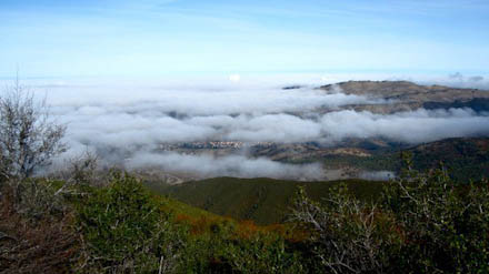
Just before the fog cleared. Photo by Korrena Bailie.
With a 2000-foot elevation gain, a mostly exposed trail and a variety of terrain, this Mount Diablo hike is wonderful to do in the cooler seasons. Spring time is particularly impressive, as the mountain is a-bloom with millions of gorgeous wildflowers. Start from the Mitchell Canyon Staging Area on the north side of the mountain – this hike offers stunning vistas of the Bay, including a peek-a-boo view of the Golden Gate Bridge, red rocky outcrops towards the summit, beautifully situated picnic tables and a host of birds, butterflies and flora, including manzanita and yerba santa. Being typically Bay Area, the views can be obscured by fog but this generally clears up by early afternoon. When I hiked there in November, I stumbled upon a cackling crowd of wild turkeys who’d obviously survived the Thanksgiving rush.
2. Point Reyes National Seashore – Tomales Point Trail (11.4 mi. / 18.3 km)
Level: Easy to moderate
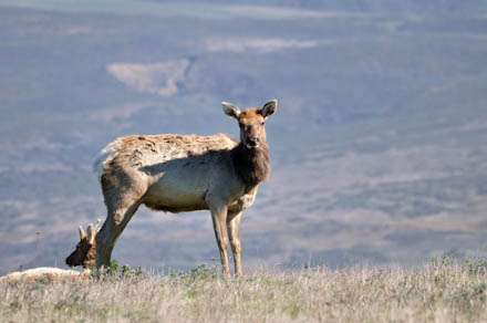
Photo by Don DeBold. CC BY 2.0
Don’t be put off by the length of this hike – very little elevation is gained or lost and it’s one of the most unique hiking experiences in the Bay Area. On the peninsula at Tomales Point is a herd of over 400 tule elk, a breed that was native to California. In 1978, the elk were released from a breeding program into the Tomales Point enclosure and they have thrived ever since. On this meandering hike, which gives outstanding views of the ocean, you can get up close and personal with the elk, who are largely unbothered by the presence of curious hikers. On the weekend, a park docent is stationed above a popular elk gathering point, armed with binoculars and a keenness to answer any questions you might have. This hike can get very foggy, which means that an elk may be much closer than you think (I jumped a mile when a male bugled only a couple of meters away from me) and the winds can get oppressively strong, so be sure to bring appropriate clothing.
3. Armstrong Woods State National Reserve – East Ridge Trail to Bullfrog Pond Campground. (9 mi. / 14.5 km)
Level: Moderate
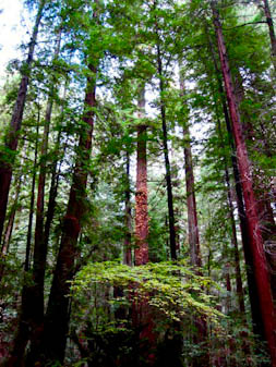
Coastal redwoods. Photo by Korrena Bailie.
Sadly, this state park has been adversely affected by lack of funding and many of its services have been affected. The campgrounds are closed but luckily the park is still open to hikers. Armstrong Woods is a wonderful alternative to the tourist zoo that is Muir Woods – the grandness, scale and serenity of the redwoods can be appreciated without a cram of visitors. If you’re feeling mellow, there is a flat 1.7 mile loop through the grove, where you can crane your neck at the Parson Jones Tree, which is a staggering 310 feet tall. Or feel young and insignificant next to the oldest tree, the Colonel Armstrong Tree, which is a humbling 1400 years old. The East Ridge Trail hike leads you out of the grove and into the Austin Creek State Recreation Area. As you leave the coolness of the redwood grove behind, the vegetation thins and the vistas open up after a steady 1500-foot elevation gain. The hike finishes at the Bullfrog Pond Campground, which has a cluster of picnic tables at the pond’s shore, perfect for polishing off your lunch before the descent.
4. Mt. Tamalpais to Stinson Beach (7 mi / 11.27 km)
Level: Moderate to strenuous
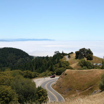
This Mount Tamalpais State Park hike is a reverse of the popular Stinson Beach Steep Ravine Loop; while it may seem a little counter-intuitive to descend for the first half of your hike and leave the ascent for last, it’s worth it to deal with less trail traffic. I enjoy pretending it’s like the Grand Canyon. This hike starts from the Pantoll Station parking lot – the first part is a narrow trail through rippling grasslands, with phenomenal views of the ocean. The trail dips down through oak forests, before emerging back into grassy plains. The trail leads into the thicker forest of the Matt Davis Trail which eventually spits you out onto the road to Stinson Beach. Hikers can picnic on the beach and build up their strength before the admittedly tough hike back to the parking lot. This is one of the most consistently beautiful hikes I have done in the Bay Area. One tip: the grass grows close to the trail and can be tall and a little sharp, so it’s advisable to wear pants rather than shorts.
5. Angel Island State Park (5 mi / 8km)
Level: Easy to moderate
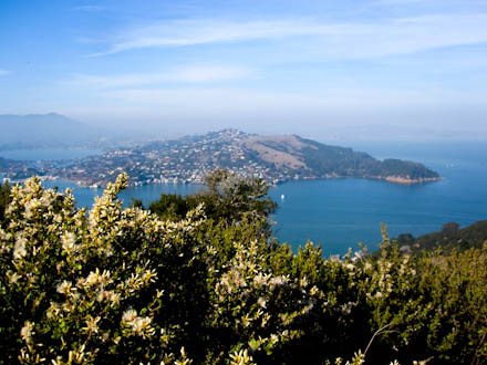 View from Mt. Livermore. Photo by Korrena Bailie.
A surprising number of Bay Area residents haven’t been to Angel Island State Park, and frankly, this is a crying shame. Firstly, you get to take a ferry to the island from sleepy, charming Tiburon. Secondly, from this ferry, you might spot harbor porpoises, seals and swooping lines of cormorants and pelicans. Thirdly, the views from Angel Island of the Bay and San Francisco are astonishingly lovely. There are two main trails, both around 5 miles long, that hikers can tackle – the blue loop and the green loop. The blue loop leads to the top of Mount Livermore, a steady 700-foot ascent that is just physically challenging enough to make the gorgeous view of Alcatraz, the SF city skyline and the Golden Gate Bridge even more rewarding. The green loop circumnavigates the island and is available for both hikers and cyclists; it passes many fascinating historical sites including a Nike missile site and the immigration station where Japanese WWII prisoners of wars were held. Keep an eye out for black-tailed deer, who apparently reached Angel Island by swimming there. Given the fact that the Bay is riddled with sharks, this is a pretty astonishing feat.
RELATED LINKS:
Do you have a favorite Bay Area hike you’d like to share? Let us know in the comments section, or via Facebook and Twitter!
[twitter style=”vertical” url=”http://tinyurl.com/6luvsdf” source=”cityseekr” text=”Super Sweet Bay Area Hikes” float=”left”] [fbshare url=”http://tinyurl.com/6luvsdf” type=”button”]